Humboldt Waterkeeper
  • About Us
    • Our Mission
    • Waterkeeper Alliance
  • Humboldt Bay
    • Geography
    • Wildlife
    • Bay Issues
    • Photo Gallery
  • Programs
    • Toxics Initiative
    • Water Quality
    • Bay Tours
    • Community Outreach
  • Get Involved
    • Report Pollution
    • Speak Out
    • Volunteer
    • Donate
    • Membership
    • Stay Informed
  • Contact Us
  • News
    • Latest
    • Press

Sea Level Rise

The Humboldt Bay area is experiencing the fastest rate of relative sea level rise on the West Coast. That's because tectonic activity is causing the ground beneath the bay to sink at the same rate that the ocean is rising. According to the California Ocean Protection Council's 2024 Science & Policy Update, sea level in the Humboldt Bay area is expected to rise approximately 1.5-2 feet above 2000 levels by 2060 and 3.9-5.5 feet by 2100. 
The primary impacts from sea level rise are increases in flooding, erosion, and rising groundwater. Sea level rise will expand areas vulnerable to flooding during major storms, as well as in the rare but catastrophic event of a major tsunami. The term 100-year flood is used as a standard for planning, insurance, and environmental analysis. But these extreme storms are happening with increasing frequency, in part due to rising seas. Sea level rise will cause more frequent—and more damaging—floods to those already at risk and will increase the size of the coastal floodplain, placing new areas at risk to flooding.
To view sea level rise scenarios for the Humboldt Bay area, visit NOAA's 2022 Sea Level Rise Viewer and go to the local scenario for the North Spit.     

Interactive Map of King Tide Photos

The California Coastal Commission's King Tide Photo Project features photos from the Humboldt Bay area and across the state. Anyone can upload photos online or via a smartphone app. Click HERE to upload yours.
Wondering about good spots to view the King Tides around Humboldt Bay? Visit our Humboldt Bay King Tide Photo Project.

Left: Erosion along New Navy Base Road in Samoa during the December 23-24, 2022 King Tides. Photo by Jen Kalt.

Sea Level Rise Vulnerability Assessment of Contaminated Sites

Details
HBK
In the News
14 October 2013
Created: 14 October 2013

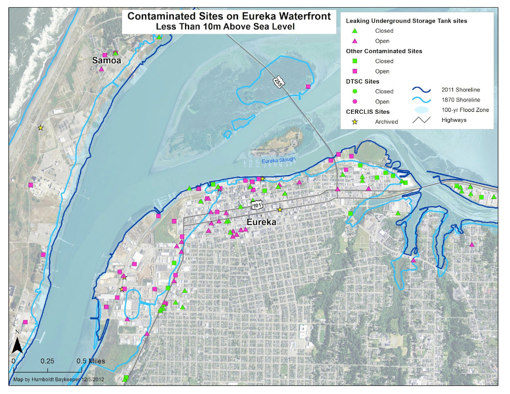
How we will prepare for rising sea levels is just beginning to take shape here in the Humboldt Bay region. Humboldt Baykeeper has assessed sea level rise vulnerability for contaminated sites near Humboldt Bay. More than 300 contaminated sites are within 10 meters of current sea level, including more than 40 that are below 2 meters – the amount sea level is projected to rise by the year 2100.

Read more …

Humboldt Bay Sea Level Rise Adaptation Planning Project

Details
HBK
In the News
11 October 2013
Created: 11 October 2013

Phase I: Shoreline Inventory, Mapping, and Vulnerability Assessment

A report to the State Coastal Conservancy by Aldaron Laird, Brian Powell, and Jeff Anderson.

Click below to download the report:

Humboldt Bay Shoreline Inventory, Mapping and SLR Vulnerability Assessment (PDF, 45 MB)

Addendum: Dike and Railroad Shoreline Vulnerability Rating


Read more …

San Francisco: a Test Case for Coping with Rising Seas

Details
Molly Samuel, KQED
In the News
11 February 2013
Created: 11 February 2013

2/1/13

Parts of New York and New Jersey are still reeling from Superstorm Sandy, an event that brought climate change and the threat of sea-level rise front-and-center. It's a looming problem for all coastal cities, and one that San Francisco has been pondering since long before Sandy struck. Along San Francisco’s western shore, the Ocean Beach Master Plan is a kind of test case for sea-rise planning. It calls for big changes, including a strategy known as managed retreat.

Read more …

Biggest tides of the year set to hit California

Details
Paul Rogers, San Jose Mercury News
In the News
13 December 2012
Created: 13 December 2012

12/12/12


If you head down the beach this week, or wander along the edges of San Francisco Bay, you may just be witnessing California's future.


The ocean is getting closer.

Read more …

East coast flooding: Wake up call for Humboldt County

Details
Kevin Forestieri, HSU Lumberjack
In the News
08 December 2012
Created: 08 December 2012

11/28/12


This year America watched sea levels rise and the ocean flood cities across the east coast in late October. Humboldt County faces a similar threat.
 
Mid-November to early December is when flood risk is the highest. A storm during the high tides of that time can overtake the dikes around Humboldt Bay, flood the area and cost the county millions of dollars to recover.

Read more …

More Articles …

  1. Supervisors back study of rising sea; Bay infrastructure threatened
  2. Rising Seas Pose Risks Around Humboldt Bay
  3. California faces more serious risk of sea level rise than other areas
  4. Rising sea levels around Humboldt Bay

In the News

King Tide Photo Initiative

  • Start
  • Prev
  • 8
  • 9
  • 10
  • 11
  • 12
  • 13
  • 14
  • 15
  • 16
  • 17
  • Next
  • End

Advanced Search

Current Projects

  • Mercury in Local Fish & Shellfish
  • Nordic Aquafarms
  • Offshore Wind Energy
  • Sea Level Rise
  • 101 Corridor
  • Billboards on the Bay
  • Dredging
  • Advocacy in Action
  • Our Supporters
Report A Spill
California Coastkeeper
Waterkeeper Alliance
Copyright © 2025 Humboldt Waterkeeper. All Rights Reserved.