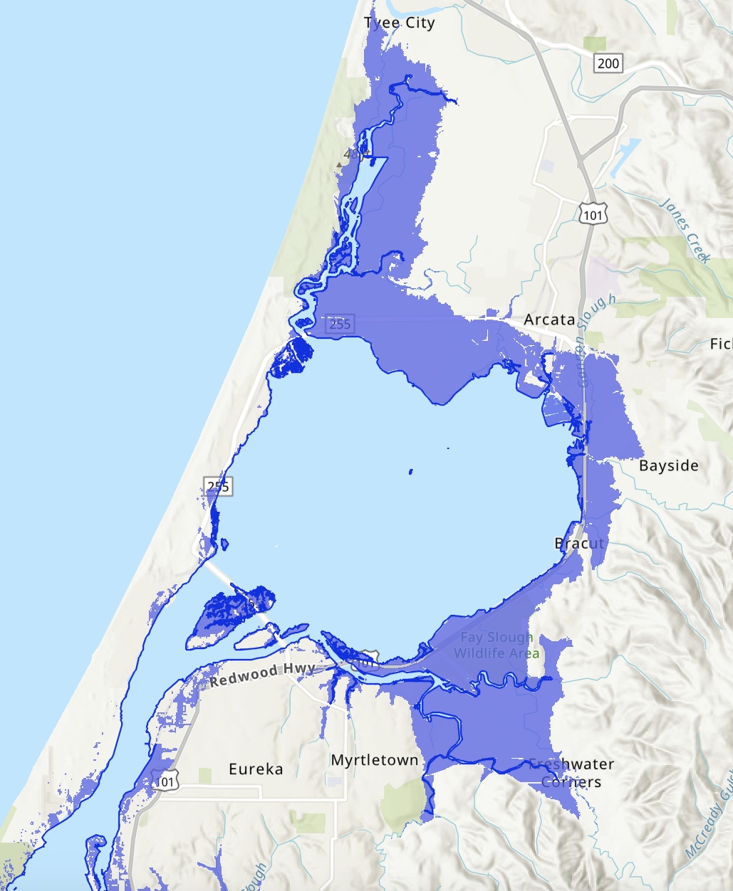
The Humboldt Bay area is experiencing the fastest rate of relative sea level rise on the West Coast. That's because tectonic activity is causing the ground beneath the bay to sink at the same rate that the ocean is rising. According to the California Ocean Protection Council's 2024 Science & Policy Update, sea level in the Humboldt Bay area is expected to rise approximately 1.5-2 feet above 2000 levels by 2060 and 3.9-5.5 feet by 2100. The primary impacts from sea level rise are increases in flooding, erosion, and rising groundwater. Sea level rise will expand areas vulnerable to flooding during major storms, as well as in the rare but catastrophic event of a major tsunami. The term 100-year flood is used as a standard for planning, insurance, and environmental analysis. But these extreme storms are happening with increasing frequency, in part due to rising seas. Sea level rise will cause more frequent—and more damaging—floods to those already at risk and will increase the size of the coastal floodplain, placing new areas at risk to flooding. To view sea level rise scenarios for the Humboldt Bay area, visit NOAA's 2022 Sea Level Rise Viewer and go to the local scenario for the North Spit. NEW! Now you check out our interactive map of two sea level rise scenarios for the Humboldt Bay Area! Featured are scenarios showing 1- and 2-meters above Year 2000 water levels. For many years, these have been static maps with no simple way for the public to examine points of interest. Now, people wondering if their neighborhood is at risk can zoom in on locations and see street names, etc.
Starting in 1890, 40% Wigi (Humboldt Bay) was diked to convert public trust tidelands to private agricultural uses. Now 136 years later, sea level rise is enabling Wigi to begin reclaiming its stolen lands. In January, record King Tides breached a dike along Baduwa’t (Mad River) Slough. Photo by Todd Van Herpe, 2/2/26.
Read more …
The first draft of a big update to a 1980s-era Humboldt County planning document was released this week.The Humboldt Bay Area Plan Update, which sets the policy direction for land use of 21,500 acres in the unincorporated bay area and over 20 miles of coastline, has new modifications aimed at guiding the future of the region through a spread of projected hazards and opportunities. This draft has added guidelines for addressing hazards like sea level rise and tsunamis, and proposes new policies to set a process for approving offshore wind energy support facilities.
Read more …
Nearly two weeks after King Salmon and Fields Landing were inundated with record-breaking floodwaters, many residents are still struggling to recover, with some facing tens of thousands of dollars in property damage.Among them are Linda and James Carter. The pair moved into their King Salmon home — a little light blue house just a stone’s throw away from the beach — shortly after they were married in 2010. In their 15-plus years in King Salmon, the Carters have seen their neighborhood flood countless times during storms and high tides, but they never worried much about their own home because a brick retaining wall surrounds the property.
Read more …
Has Saturday's highest King Tide on record gotten you wondering how our neighborhoods, roads, and open space will fare as sea level rises? Now you check out our interactive map of two sea level rise scenarios for the Humboldt Bay Area! Featured are scenarios showing 1- and 2-meters above Year 2000 water levels. For many years, these have been static maps with no simple way for the public to examine points of interest. Now, people wondering if their neighborhood is at risk can zoom in on locations and see street names, etc. King Tides are usually a time to consider how high a typical high tide will be with one foot of sea level rise, but this weekend's high tides were nearly three feet higher than the Mean Higher High Water at the North Spit. Note that this is the preliminary water level from the National Weather Service, which will verify that figure in a few weeks.
Read more …
Homes and businesses in King Salmon continue to be affected by the ongoing historic high tides and the coming storm system, which saw no break Saturday, as record-breaking tides hit.According to Troy Nicolini of the Eureka National Weather Service, “We have a really high astronomical tide today combined with pretty significant storm surge, as high as it gets, and we’ll get it somewhere in the 10.1-10.3 (foot) range at about 10:45 at its north-spit gauge across the bay from King Salmon. That’s a record-breaking high tide for today, and when we were talking to people there in King Salmon they’ve said it’s the highest they’ve ever seen, which confirms our measurements.”
Read more …
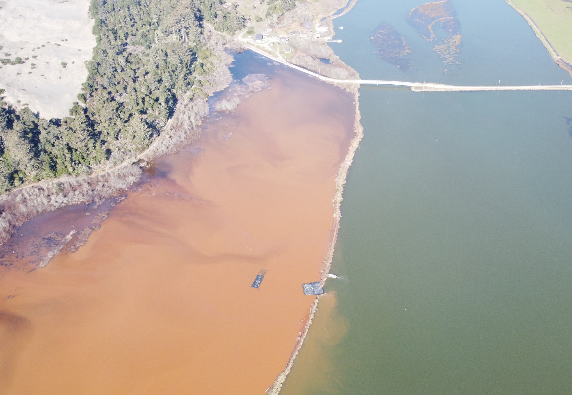 Starting in 1890, 40% Wigi (Humboldt Bay) was diked to convert public trust tidelands to private agricultural uses. Now 136 years later, sea level rise is enabling Wigi to begin reclaiming its stolen lands. In January, record King Tides breached a dike along Baduwa’t (Mad River) Slough. Photo by Todd Van Herpe, 2/2/26.