Humboldt Waterkeeper
  • About Us
    • Our Mission
    • Waterkeeper Alliance
  • Humboldt Bay
    • Geography
    • Wildlife
    • Bay Issues
    • Photo Gallery
  • Programs
    • Toxics Initiative
    • Water Quality
    • Bay Tours
    • Community Outreach
  • Get Involved
    • Report Pollution
    • Speak Out
    • Volunteer
    • Donate
    • Membership
    • Stay Informed
  • Contact Us
  • News
    • Latest
    • Press

Sea Level Rise

The Humboldt Bay area is experiencing the fastest rate of relative sea level rise on the West Coast. That's because tectonic activity is causing the ground beneath the bay to sink at the same rate that the ocean is rising. According to the California Ocean Protection Council's 2024 Science & Policy Update, sea level in the Humboldt Bay area is expected to rise approximately 1.5-2 feet above 2000 levels by 2060 and 3.9-5.5 feet by 2100. 
The primary impacts from sea level rise are increases in flooding, erosion, and rising groundwater. Sea level rise will expand areas vulnerable to flooding during major storms, as well as in the rare but catastrophic event of a major tsunami. The term 100-year flood is used as a standard for planning, insurance, and environmental analysis. But these extreme storms are happening with increasing frequency, in part due to rising seas. Sea level rise will cause more frequent—and more damaging—floods to those already at risk and will increase the size of the coastal floodplain, placing new areas at risk to flooding.
To view sea level rise scenarios for the Humboldt Bay area, visit NOAA's 2022 Sea Level Rise Viewer and go to the local scenario for the North Spit.     

Interactive Map of King Tide Photos

The California Coastal Commission's King Tide Photo Project features photos from the Humboldt Bay area and across the state. Anyone can upload photos online or via a smartphone app. Click HERE to upload yours.
Wondering about good spots to view the King Tides around Humboldt Bay? Visit our Humboldt Bay King Tide Photo Project.

Left: Erosion along New Navy Base Road in Samoa during the December 23-24, 2022 King Tides. Photo by Jen Kalt.

Perils of Climate Change Could Swamp Coastal Real Estate

Details
Ian Urbina, New York Times
In the News
01 January 2017
Created: 01 January 2017

Homeowners are slowly growing wary of buying property in the areas most at risk, setting up a potential economic time bomb in an industry that is struggling to adapt.


11/24/16


MIAMI — Real estate agents looking to sell coastal properties usually focus on one thing: how close the home is to the water’s edge. But buyers are increasingly asking instead how far back it is from the waterline. How many feet above sea level? Is it fortified against storm surges? Does it have emergency power and sump pumps?


Rising sea levels are changing the way people think about waterfront real estate. Though demand remains strong and developers continue to build near the water in many coastal cities, homeowners across the nation are slowly growing wary of buying property in areas most vulnerable to the effects of climate change.

 

Read more …

‘Arcata is not going to be here’ – city to adapt, protect and retreat from sea level rise

Details
Kevin Hoover, Mad River Union
In the News
28 December 2016
Created: 28 December 2016

12/25/16


“By 2050, this will be normal,” said Aldaron Laird, standing near the top of an Arcata wastewater treatment pond levee as waves broke at his feet.


A small group had trekked out to the Rising Tides Bench during a nine-foot King Tide on Dec. 13 for a discussion of sea level rise, its imminence and consequences.


While the bay’s present borders can more or less withstand today’s King Tides – also known as perigean spring tides, which coincide with maximum gravitational pull by the moon and sun – that won’t be the case when they ride in on top of tomorrow’s raised sea levels. At that point, seawater would overtop current levees and inundate coastal areas, including homes, farms, businesses and critical public infrastructure.


The higher sea levels are not an “if,” they’re a “when.” What we don’t know is exactly when.

Read more …

Eureka Plans to Flout Coastal Commission Recommendations on Sea Level Rise

Details
Ryan Burns, Lost Coast Outpost
In the News
20 November 2016
Created: 20 November 2016

11/18/16


The images are dramatic, showing some of Eureka’s most important areas completely submerged in water. The Bayshore Mall, Costco, Schmidbauer Lumber, even parts of Old Town and Highway 101 would lie beneath the surface of the ocean according to the worst-case-scenario projections for sea level rise and tectonic subsidence by the year 2100 in a new draft report prepared for the City of Eureka.


Read More

Humboldt Bay Sea Level Rise Inundation Mapping

Details
HBK
In the News
26 February 2015
Created: 25 January 2015

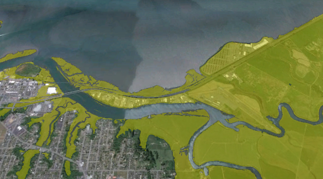
Inundation maps were developed by Jeff Anderson of Northern Hydrology & Engineering for the Humboldt Bay Sea Level Rise Vulnerability Assessment Project. The maps show areas vulnerable to existing and future sea levels that are currently protected from inundation due to the natural shoreline, dikes or berms, and railroad or road grades.

Read more …

Obama Moves To Protect Against Flooding From Rising Sea Levels

Details
Kate Sheppard, Huffington Post
In the News
01 February 2015
Created: 01 February 2015

1/30/15

President Barack Obama issued an executive order on Friday directing federal, state and local agencies to incorporate projections for sea level rise in planning and construction along the coasts.


The new Federal Flood Risk Management Standard requires that all federally funded projects located in floodplains, including buildings and roads, be built to withstand flooding. The requirement, the White House said in a release Friday, would “reduce the risk and cost of future flood disasters” and “help ensure federal projects last as long as intended.”

Read more …

More Articles …

  1. King Tides are back sans storms
  2. King tides hit coast, cause minor flooding
  3. The old man and the rising sea
  4. How will we plan for Sea Level Rise? Mon. Nov. 17, 2014

In the News

King Tide Photo Initiative

  • Start
  • Prev
  • 5
  • 6
  • 7
  • 8
  • 9
  • 10
  • 11
  • 12
  • 13
  • 14
  • Next
  • End

Advanced Search

Current Projects

  • Mercury in Local Fish & Shellfish
  • Nordic Aquafarms
  • Offshore Wind Energy
  • Sea Level Rise
  • 101 Corridor
  • Billboards on the Bay
  • Dredging
  • Advocacy in Action
  • Our Supporters
Report A Spill
California Coastkeeper
Waterkeeper Alliance
Copyright © 2025 Humboldt Waterkeeper. All Rights Reserved.