No major flooding expected due to good weather
12/29/13
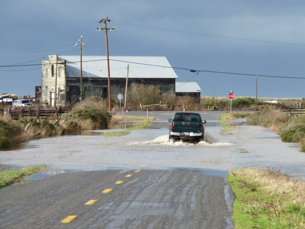
The highest and lowest tides of the year — commonly known as king tides — will hit North Coast beaches this week, but won’t cause as much of a splash as in previous years, according to National Weather Service meteorologist Alex Dodd.
“We’re not expecting any major coastal flooding like what happened in 2005 and 2006,”Dodd said. “But on places like the jetty and steeper beaches, the water level will be substantially higher.”
Dodd said king tides arise from the gravitational forces resulting from when the “Earth is closest to the sun and the moon is closest to the Earth.”
This year’s king tides are predicted to range from 8.29 feet to 8.65 feet above the Mean Lower Low Water mark — lower than the average of 8.79 feet — and will mostly remain at those heights due to good weather, Dodd said.
“We have a great big ridge of high pressure that has kept any storms well to our north,” Dodd said. “Fortunately or unfortunately, depending on your perspective, we won’t have any rain or southerly winds during that time, so the tide levels will be close to what’s being predicted.”
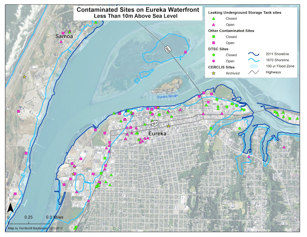
For Humboldt Baykeeper policy director Jennifer Kalt, king tides provide a visualization of the impacts of rising sea levels on habitats and infrastructure near Humboldt Bay.
“The Humboldt Bay area has a lot of really low-lying areas and double the sea rise effect due to its seismic activity,” Kalt said. “It’s a problem happening right now. It’s not going to happen slowly over time.”
As a way to display these impacts, Humboldt Baykeeper started their King Tide Photo Initiative in 2012 to create a visual database illustrating how the temporary rise in sea level caused by king tides can effect areas near the bay. The photos are mainly submitted by volunteers who photograph structures being hit by the abnormally high tides.
For this year’s initiative, Kalt plans to expand the number of areas photographed as well as revisit some of the areas photographed last year.
Kalt said that the issue of sea level rise will go beyond infrastructure.
“We’ve already lost about 90 percent of our coastal wetlands,” she said. “All the salt marshes in Humboldt Bay have levees that won’t be able to sustain the amount of water. As the sea level rises, the wildlife living in the wetlands and eelgrass beds will have to move inland.”
Aldaron Laird, an environmental consultant for the Humboldt Bay Sea Level Rise Adaptation Planning Project, said that it is important for people to see king tides for themselves.
“I encourage people to go out to Humboldt Bay to see how full the bay is with just 1 foot of sea level rise,” Laird said. “Humboldt Bay is pretty much filled to capacity — it won’t have the ability to contain 2 or 3 more feet.”
In January, Laird completed a study funded by the California Coastal Conservancy on the effects of sea level rise on Humboldt Bay. The study referenced a 2012 study from the University of California Santa Cruz, which found that Humboldt Bay had the highest rate of sea level rise in California at 18.6 inches per century — more than twice the state average, according to Laird.
Laird’s study also showed that since 1977, 12 king tide events have exceeded the average of 8.79 feet for Humboldt Bay, with seven of those occurring since 2000.
Dodd said he has not seen any abnormal changes in king tides over the years, but said sea level rise will have an impact on them.
“The common sense answer is if the sea level rises, then that is going to result in a higher water level and tides on top of that,” he said.
For the North Spit of Humboldt Bay, high tides are expected to reach 8.29 feet at 9:09 a.m. on Monday, 8.56 feet at 10 a.m. on Tuesday, 8.65 feet at 10:52 a.m. on Wednesday and 8.54 feet at 11:42 a.m. on Thursday, according to tide predictions from the NOAA Tides and Currents website.
Those interested in participating in the Humboldt Baykeeper King Tide Photo Initiaive are asked to contact the organization online at This email address is being protected from spambots. You need JavaScript enabled to view it. or call 707-268-8897.
Read Original Article
 The Humboldt Bay Harbor, Recreation, and Conservation District and Humboldt County Public Works Department invite the public to an informational meeting on planning for the potential effects of sea level rise around Humboldt Bay. The meeting will be held on Tuesday, November 12, from 6 to 8 p.m. at the Humboldt Bay Aquatic Center, room 203, 921 Waterfront Drive, Eureka.