Phase I: Shoreline Inventory, Mapping, and Vulnerability Assessment
A report to the State Coastal Conservancy by Aldaron Laird, Brian Powell, and Jeff Anderson.
Click below to download the report:
Humboldt Bay Shoreline Inventory, Mapping and SLR Vulnerability Assessment (PDF, 45 MB)
Addendum: Dike and Railroad Shoreline Vulnerability Rating
This project constitutes the first phase of a multi-phase sea level rise adaptation planning effort for Humboldt Bay. To develop a sea level rise adaptation plan, it is necessary to understand the vulnerability to and risk from sea level rise. There is time to plan and adapt to sea level rise, but the longer we wait, the more likely we will have to deal with extensive emergency flooding.
Since the 1880s, Humboldt Bay has had a historical legacy of diking and “reclaiming” nearly 9,000 acres of tidelands. There currently are reaches of earthen dikes on Humboldt Bay that are actively eroding, unmaintained, or are overtopped by extreme high tides, making these areas vulnerable to erosion and flooding. Since 2000, Humboldt Bay has experienced periods of rising water elevations on the order of 1 to 1.75 feet during annual extreme high tides and when combined with either stormwater runoff or storm surges.
With artificial shorelines covering 75% of Humboldt Bay (76.7 miles), only 36% is fortified (27.6 miles). Vulnerable shoreline structures, such as dikes, put low-lying infrastructure and property at risk from flooding. At great expense, fortification of diked shorelines has been a common response to recently breached or overtopped dikes. On Arcata Bay, for example, fortification and rehabilitation of dikes cost $900,000 to $2,000,000 per mile, without any significant increase in elevations. These fortified dikes will not be able to withstand projected sea level rise above 3 or 6 feet.
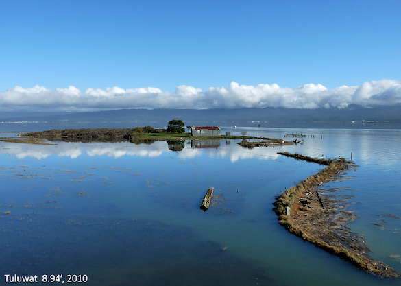
At right: Indian Island at 8.94' high tide, 2010. Photo by Aldaron Laird.
Former tidelands have been and continue to be productive areas for agriculture, but at some time in the future, rising tides or continued subsidence of the land will elevate groundwater and existing tidegates will no longer fully drain on ebbing tides. Eventually, rising tides and subsiding land may reclaim some of the nearly 9,000 acres of former tidelands as the Bay returns to its original footprint.
While it is not known if sea level rise or subsidence will continue at the same rate as has been recorded at the North Spit tide station, it would be prudent for the Humboldt Bay region to initiate adaptation plans before water levels reach the two to three foot threshold when wide-spread shoreline failure of approximately 21 to 44 miles could occur, and land uses, infrastructure, and resources, currently protected, will be at risk of permanent flooding. In the long-term, with a 6 foot rise in water levels, nearly 94% of the dikes would fail to hold back rising tidewater.
The State Coastal Conservancy has funded the Coastal Ecosystems Institute of Northern California (CEI) to implement Phase II of the Humboldt Bay Sea Level Rise Adaptation Planning Project. CEI has contracted with Jeff Anderson of Northern Hydrology and Engineering, who is just now gearing up to prepare relative sea level rise inundation maps and a groundwater model that will be used by an Adaptation Planning Working Group that is the process of coming together this Spring. The Humboldt Bay Harbor, Recreation and Conservation District is under contract with CEI to convene the Working Group and with Humboldt County and during the next two years will explore regional adaptation strategies that could be implemented on Humboldt Bay in response existing and future vulnerabilities from sea level rise.


