Researchers from the Department of Energy’s (DOE’s) Pacific Northwest National Laboratory (PNNL) and environmental consulting firm H. T. Harvey & Associates recently deployed technology off the West Coast in one of the first efforts to understand how high seabirds fly and whether they might interact with wind turbines and other infrastructure. They published the research on April 24 in Frontiers in Marine Energy.“This is an important step in understanding seabird behavior at the height of offshore wind turbines on the West Coast,” said Shari Matzner, computer scientist at PNNL and coauthor on the paper. Data from scientists on research vessels have provided estimates of how high birds fly, depending on wind strength, but “this is really the first time we’ve had real-time, quantified flight height data for these birds,” Matzner said.Keep reading
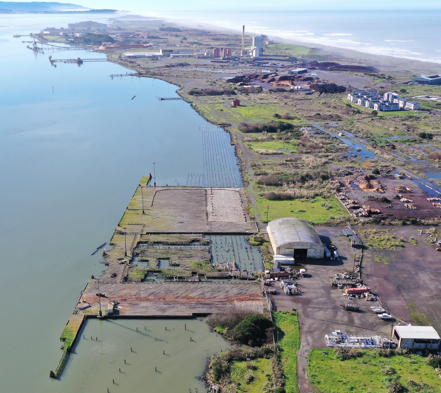
The federal government recently awarded $426,000,000 to the Humboldt Bay Harbor, Recreation, and Conservation District for the design, permitting, and construction of an offshore wind Heavy Lift Terminal on the Samoa Peninsula. Left: The site was once part of the former Hammond Lumber Mill. The site will need to be remediated, dock and buildings demolished, and ground elevation raised to accommodate sea level rise. Imagery by Oren Nardi for Humboldt Waterkeeper.
Read more …
A little over a month ago, during high tide, huge chunks of the bluff at Fleener Creek Overlook flaked off in powdery sheets, falling nearly 100 feet to Centerville Beach, where waves lapped at the accumulating mountains of fallen silt and dirt. The collapse, which took a big section of parking lot with it, sent people running, as seen in dramatic drone video. The county later declared a state of emergency.On Friday, a smaller version of this natural drama took place at the Bay Street parking lot on the Samoa Peninsula. The pounding waves of high tide, which have been eating away at the dune slope to form temporary coastal cliffs up and down the peninsula, undercut the asphalt until a big sections fell onto the beach below.In response, the County of Humboldt closed the popular parking spot, commonly called “the T,” and the Samoa Peninsula Fire District issued a public safety warning, urging people to urge extreme caution on all local beaches due to the steep and still-eroding banks.Keep Reading
By the time researchers found the dead whale on a Martha’s Vineyard beach, her jet-black skin was pockmarked by hungry seagulls, her baleen had been dislodged from her mouth, and thin rope was wrapped tightly—as it had been for 17 months—around the most narrow part of her tail.Researchers quickly learned this was a 12-ton, 3-year-old female known as 5120, and that she was a North Atlantic right whale, a species with just about 360 members left.A few weeks later, NOAA Fisheries announced that the entangling rope came from lobster fishing gear set in Maine state waters. The pain and discomfort of the entanglement likely affected 5120’s ability to swim and eat until finally, experts say, exhaustion or starvation probably killed her. A final cause of death is still pending.The death of 5120 was devastating to right whale advocates, who know that losing a female doesn’t just mean losing one whale, but dozens of others that could have come from her future calves. For them, a death is often followed by a period of grief, and a renewed commitment to their work. And that might have been the end of 5120’s story.But then came the online comments. Hundreds, perhaps thousands, across social media blamed offshore wind farms—the noise, electricity generated, and the mere presence of turbines. Along the way, the truth about 5120 became a non-concern.Keep Reading
California’s Division of Boating and Waterways (DBW) alleges that Cal Poly Humboldt has been misusing the Humboldt Bay Aquatic Center (HBAC) for its scenic views and now swanky administrative office space – thanks to a recent $412,000 renovation. The university is not, the breach of contract notice charges, fulfilling its commitment to boating instruction and safety training.“[Cal Poly Humboldt] is not using the [HBAC] for the purposes for which the building was funded, or for which the property was leased from the city and approved by the state lands commission,” stated a notice of breach of contract notice sent to Cal Poly Humboldt President Tom Jackson Jr. in Dec. 2023. The notice outlined the key problem – that without notice nor written approval, which is required by the operating agreement, Cal Poly Humboldt transformed boater-funded classrooms, offices and storage spaces into alumni fundraising offices, private club rowing, storage of private club vessels and support for private university fundraising activities.In understanding the breach of contract, it is helpful to recognize the complex web of involvement at the HBAC between the city of Eureka, the state of California and Cal Poly Humboldt. In summary, the Department of Boating and Waterways put forth $4.067 million to fund the construction of the facility, as well as $702,000 since 2003 to offset the costs of the university’s ongoing boating instruction and safety training. Cal Poly Humboldt leases the land the facility sits upon from the city of Eureka. Though the HBAC is fully owned and operated by the university, an operating agreement between the DBW and the university, as well as a lease agreement between Eureka and the university, outline specific guidelines for the expected uses of the facility, many of which have not been fulfilled by the university, according to DBW.Read the rest of the Lumberjack articleFor more info:
 The federal government recently awarded $426,000,000 to the Humboldt Bay Harbor, Recreation, and Conservation District for the design, permitting, and construction of an offshore wind Heavy Lift Terminal on the Samoa Peninsula. Left: The site was once part of the former Hammond Lumber Mill. The site will need to be remediated, dock and buildings demolished, and ground elevation raised to accommodate sea level rise. Imagery by Oren Nardi for Humboldt Waterkeeper.

