Starting in 1890, 40% Wigi (Humboldt Bay) was diked to convert public trust tidelands to private agricultural uses. Now 136 years later, sea level rise is enabling Wigi to begin reclaiming its stolen lands. In January, record King Tides breached a dike along Baduwa’t (Mad River) Slough. Photo by Todd Van Herpe, 2/2/26.
January 2-3 King Tides: Highest on Record
Sea level is rising faster in our region than in the rest of the state because the ground beneath us is sinking due to plate tectonics. And since the dikes around the bay were built when sea level was more than 18 inches lower, they are beginning to be overtopped during King Tides —the highest tides of the year which typically occur in December and January.This winter, the King Tides in early January also coincided with winds from the south and storm surge, causing the highest tides ever documented in the Humboldt Bay area since records began in 1978. Several dikes around the bay breached, giving us a glimpse into the future as sea level continues to rise. Many of these dikes are unmaintained, meaning that they are slowly eroding in low spots until high tides eventually cause breaches, flooding the low-lying areas behind them.
Major Flooding in King Salmon
As the high tide peaked at record height on January 2-3, more than 40 homes were flooded in King Salmon, a low-lying community built along dredged canals in the 1940s. Although residents have become accustomed to occasional nuisance flooding, these high tides were much more destructive, causing major damage to homes. Many vehicles and large appliances were a total loss.
Breached Dikes in North Bay
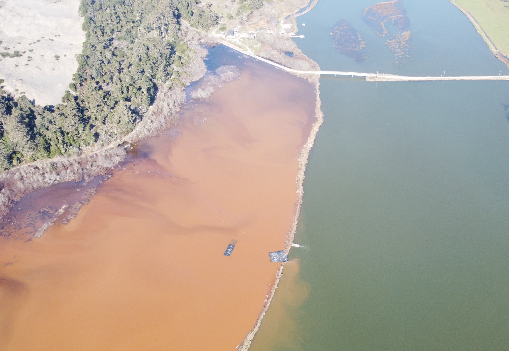
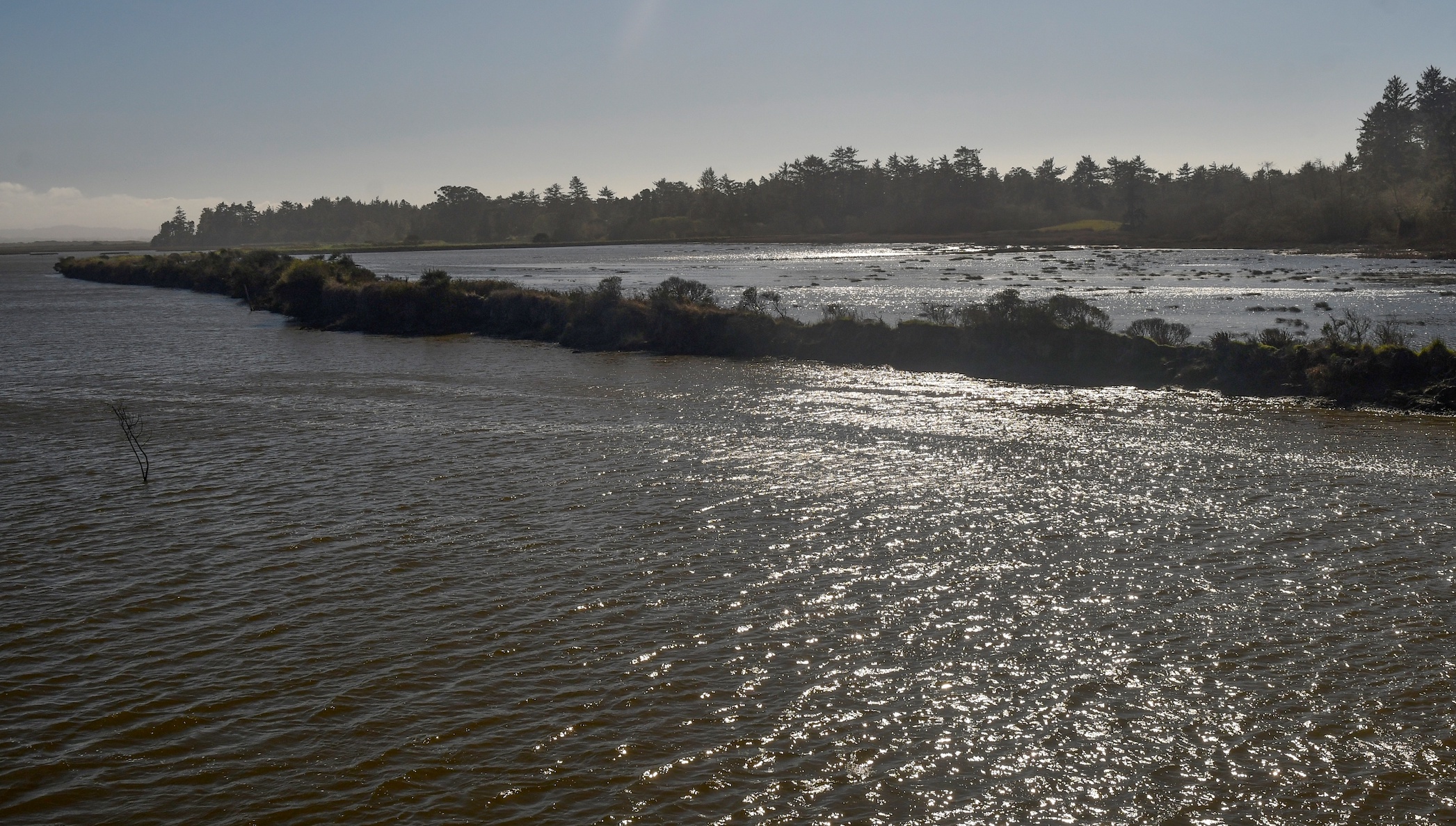
Less attention has been focused on several agricultural dikes that breached during the King Tides, flooding pasture land. The Wadulh Lagoon area on Baduwa’t Slough (Mad River Slough) is a recent example of Wigi’s reclamation of its former tidelands. In early January, the record-high King Tides breached the dike in several places, flooding approximately 40 acres of pasture land on land managed by the Humboldt Bay National Wildlife Refuge. The restoration of tide waters to this area has been planned for several years, but when the dike breached at a low spot, the water also flooded a low-lying stretch of Lanphere Road, turning it into a muddy mess.An “aquadam” was put in place at the breach in an attempt to slow the floodwaters, but it crushed the tidegate, preventing floodwaters from draining. Then at high tide, the aquadam floated away, allowing more water to get in. A month after the breach, the stagnant floodwaters turned bright orange with iron-oxidizing bacteria, which can lower dissolved oxygen and pH levels, alarming nearby shellfish growers and leading to a brief suspension of oyster harvesting throughout the bay. During normal high tides, the flooded pasture south of the Lanphere Road Bridge — now known as Wadulh Lagoon — became one with the slough, separated only by the remnants of the dike.Photo by Aldaron Laird, 3/6/26. Unlike planned restoration projects, Wigi does not need a permit or grant funding to reclaim its stolen tidelands. Unless we plan according, more flooding and breached dikes are inevitable.In May, the Coastal Commission approved an emergency permit for the U.S. Fish & Wildlife Service to temporarily rebuild the failed dike so that the restoration project could proceed. That work will hopefully be completed this summer in preparation for this winter’s high tides.As sea level rises, Wigi will continue to expand to its original extent at an accelerating pace, especially in areas where dikes are poorly maintained. And because these former tidelands have sunk by as much as three feet below their historic elevation, once they are flooded, they will become mudflats, open water, with eelgrass habitat in some areas. Where neighboring dikes are maintained, all it takes is one breach to flood adjacent lands, where the water can remain for long periods. And even if the dikes are maintained or raised, the groundwater beneath these areas is rising along with sea level, making the soil wetter for long periods while increasing salinity and eventually emerging as surface water.This is just the beginning: we will see this occur more frequently around the Wigi shoreline. For the most vulnerable areas, sea level rise is no longer a slow-moving disaster, years or decades in the futures.In mid-June, the San Francisco Bay Area saw the highest summer King Tides on record, and scientists are predicting a particularly intense El Nino this fall and winter. The California Current Marine Heatwave Tracker shows ocean temperatures above normal along our coast, and thermal expansion of sea water is expected to cause temporarily higher sea levels this winter. As we reflect on the effects of last year’s King Tide flooding, we need to prepare for the short-term while planning for the long-term.
Major Changes at Elk River Spit
The Elk River Spit in Eureka has been undergoing major changes related to rising sea level. Waves have washed over the Spit during King Tides and storms, killing the plants that once grow around a freshwater spring (at left, circled in white).Google Earth images annotated by Whelan Gilkerson.The wax myrtles and willows that once encircled the freshwater wetland on the spit were killed by saltwater. The Spit has also eroded considerably, exposing parts of the City of Eureka's discharge pipe that carries treated wastewater to the edge of the navigation channel. Photo by Aldaron Laird.
Preparing for the Future
What can we do to better prepare for increased coastal flooding and erosion? Three local governments around the bay are currently updating their coastal planning frameworks, known as Local Coastal Programs. The cities of Arcata and Eureka have been working on updates that include sea level rise policies, and will likely be bringing those policies before the Coastal Commission later this year.Humboldt County is in the process of updating its coastal planning framework for the first time since it was adopted in 1983. This plan, known as the Humboldt Bay Area Plan, will establish policies for coastal development in areas under the County’s jurisdiction. The draft includes policies addressing sea level rise, tsunamis, and other coastal hazards. You can learn more at the County’s Humboldt Bay Area Plan webpage.Stay tuned for upcoming opportunities for public input — if you are not on our email list, you can sign up by contacting us at This email address is being protected from spambots. You need JavaScript enabled to view it..
 Starting in 1890, 40% Wigi (Humboldt Bay) was diked to convert public trust tidelands to private agricultural uses. Now 136 years later, sea level rise is enabling Wigi to begin reclaiming its stolen lands. In January, record King Tides breached a dike along Baduwa’t (Mad River) Slough. Photo by Todd Van Herpe, 2/2/26.
 During normal high tides, the flooded pasture south of the Lanphere Road Bridge — now known as Wadulh Lagoon — became one with the slough, separated only by the remnants of the dike.Photo by Aldaron Laird, 3/6/26. Unlike planned restoration projects, Wigi does not need a permit or grant funding to reclaim its stolen tidelands. Unless we plan according, more flooding and breached dikes are inevitable.In May, the Coastal Commission approved an emergency permit for the U.S. Fish & Wildlife Service to temporarily rebuild the failed dike so that the restoration project could proceed. That work will hopefully be completed this summer in preparation for this winter’s high tides.As sea level rises, Wigi will continue to expand to its original extent at an accelerating pace, especially in areas where dikes are poorly maintained. And because these former tidelands have sunk by as much as three feet below their historic elevation, once they are flooded, they will become mudflats, open water, with eelgrass habitat in some areas. Where neighboring dikes are maintained, all it takes is one breach to flood adjacent lands, where the water can remain for long periods. And even if the dikes are maintained or raised, the groundwater beneath these areas is rising along with sea level, making the soil wetter for long periods while increasing salinity and eventually emerging as surface water.This is just the beginning: we will see this occur more frequently around the Wigi shoreline. For the most vulnerable areas, sea level rise is no longer a slow-moving disaster, years or decades in the futures.In mid-June, the San Francisco Bay Area saw the highest summer King Tides on record, and scientists are predicting a particularly intense El Nino this fall and winter. The California Current Marine Heatwave Tracker shows ocean temperatures above normal along our coast, and thermal expansion of sea water is expected to cause temporarily higher sea levels this winter. As we reflect on the effects of last year’s King Tide flooding, we need to prepare for the short-term while planning for the long-term.
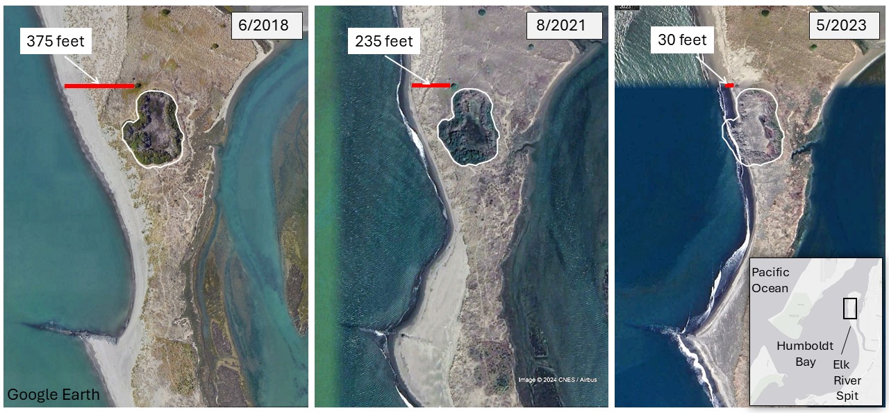 The Elk River Spit in Eureka has been undergoing major changes related to rising sea level. Waves have washed over the Spit during King Tides and storms, killing the plants that once grow around a freshwater spring (at left, circled in white).Google Earth images annotated by Whelan Gilkerson.
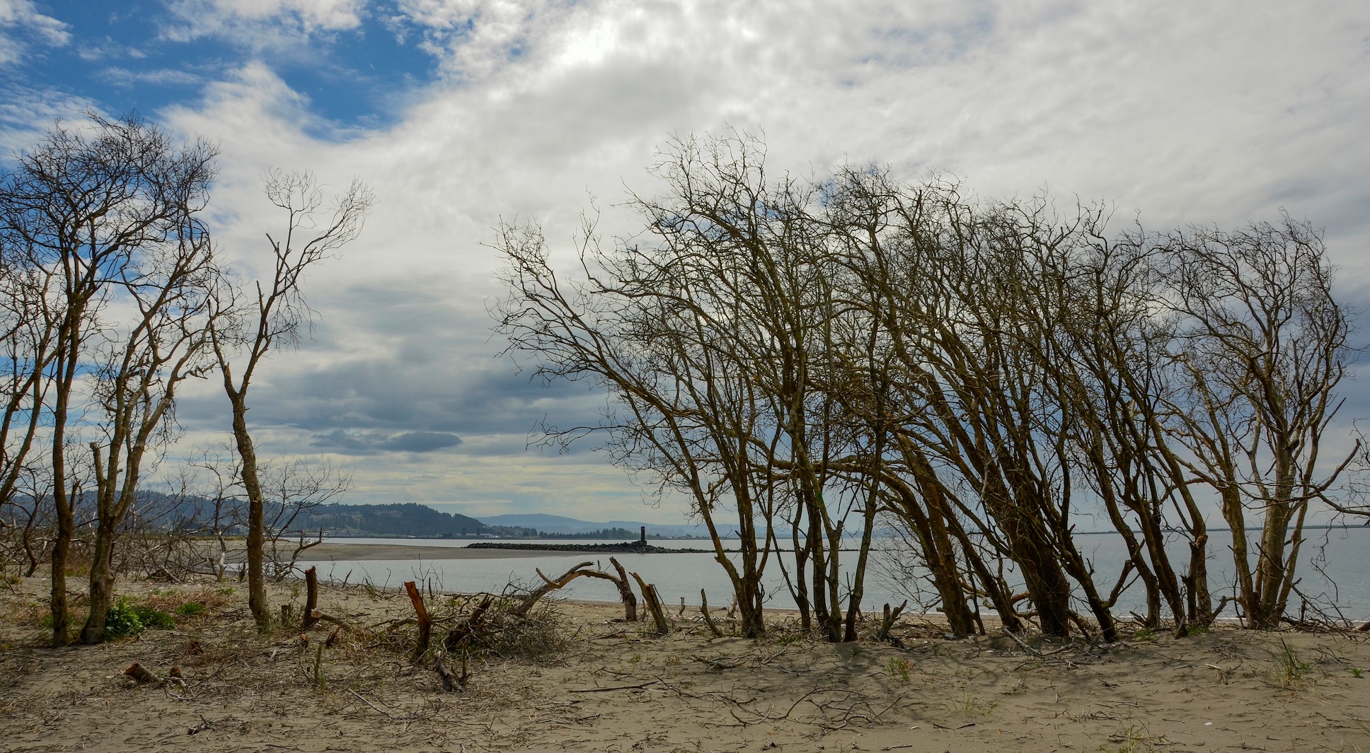 The wax myrtles and willows that once encircled the freshwater wetland on the spit were killed by saltwater. The Spit has also eroded considerably, exposing parts of the City of Eureka's discharge pipe that carries treated wastewater to the edge of the navigation channel. Photo by Aldaron Laird.


